VT Interactive Map Viewer BETA 2.0 Released

April 29, 2014

imv_beta

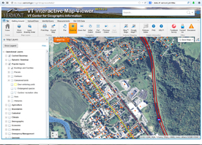
The VT Center for Geographic Information (VCGI) is pleased to announce an “open beta release” of the new VT Interactive Map Viewer (VT Viewer).

You can participate in a guided tour during the free webinar on April 30.

This BETA 2.0 release includes numerous enhancements

  • The toolbar has been rearranged to make it more intuitive.
  • The look-and-feel of the VT GIS basemap has been significantly improved.
  • Several dozen new data layers (including parcel data) have been added to the viewer.
  • User can change the symbology of any layer.
  • Complete set of VT imagery and imagery indexes.
  • Several new supplemental background basemaps have been added such as contoured hillshade and the latest USGS Topographic Maps.
  • All layers have links to full documentation and downloadable data files.

Now we need to hear from you! Please take the new VT Interactive Map Viewer (BETA 2.0) for a test drive, then let us know what you think by completing the Feedback Survey.

VT Viewer (BETA 2.0): http://dev.maps.vermont.gov/vcgi/vtmapviewerbeta2/

User Survey: http://dev.maps.vermont.gov/vcgi/vtmapviewer/survey.html

The BETA 2.0 release will be available as an “open beta” until May 31st, 2014. After that VCGI will be reviewing all survey feedback and applying any needed adjustments/fixes to the site. We plan to release the final version by July 1st, 2014. It will replace the current VT Interactive Map Viewer.

You can participate in a guided tour during the free webinar on April 30.

VCGI Notice Regarding Heartbleed Vulnerability Bug

April 22, 2014

You might be aware of a widespread software vulnerability named Heartbleed, which has affected a large number of servers on the internet.

We want to let you know that VCGI’s website (vcgi.vermont.gov), web map services (maps.vcgi.org), and mapping sites (maps.vermont.gov/vcgi/vtmapviewer) are not vulnerable to the Heartbleed bug. We have come to this conclusion by reaching out to our vendors to determine if any of their software products are vulnerable to the Heartbleed bug.

For more general information on Heartbleed, visit http://www.heartbleed.com/


VCGI Update

April 14, 2014

statehouse_0_3_2013_sm

Request for Information posted re: VT Open GeoData Portal:

The VT Center for Geographic Information (VCGI) currently hosts Vermont’s Open GeoData Portal (herein referred to as the GeoData Portal), which allows users to access and use geospatial information and services. This Request for Information (RFI) is designed to gather information from geospatial technology providers regarding the development of a new VT Open GeoData Portal. The results of the RFI may or may not lead to the release of a Request for Proposals (RFP).

The full RFI has been posted here http://vcgi.vermont.gov/rfps

NOTE: All questions related to this RFI should be emailed to steves@vcgi.org by April 28, 2014: 3PM EST. All questions and associated responses will be made publicly available by May 5, 2014: 3PM EST on VCGI’s website.

All 2013 Orthoimagery has been posted:

Ortho imagery covering the northwest portion of the state as well as the Barre-Montpelier area was collected in the spring of 2013. All of the northwest corner was collected in 4-band color infrared as well as black and white with .5 meter pixels. Additionally, much of Chittenden County was collected at a resolution of .15 meter pixels, with the more mountainous eastern edge of the county being collected at .2 meter pixels.  The Barre-Montplelier area was collected as a resolution of .3 meter pixels.  More info here: http://vcgi.vermont.gov/2013_imagery_available

Mapping it up in VT and NH (webinar) scheduled:

VT and NH both have powerful, newly updated online map viewers.  While each viewer is customized to the state’s GIS resources, they share a common framework and much of the same functionality.  Come for a tour of the new interface(s), layers and tools for both viewers. Participants in this webinar will learn how to make maps from the layers provided by VCGI and NH GRANIT, add your own data to the maps, save your map as an image or to print, and more.

Date:  Wednesday, April 30, 2014

Reserve your Webinar seat now at:
https://www3.gotomeeting.com/register/477757118