New Interactive Map Viewer Available!

January 23, 2017

imv_html5_sm

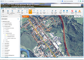
The VT Center for Geographic Information (VCGI) is pleased to release a new interactive map viewer that leverages the latest HTML5 capabilities and GIS data. Here are some key features of the new Map Viewer.

Key Features
  • Supported on all modern web browsers on desktop computers, tablets and phones.  No plugins!
  • Save your map via “Save” button (NOTE: must sign-in to ArcGIS Online account first – available for free).
  • Lidar terrain / hillshade data (~50% of the state).
  • Access to VCGI Open Data via a Layer Catalog
  • Download the data layers from the Table of Contents (refer to FAQ for details).
  • Determine when aerial photos were taken (refer to FAQ for details)
  • Change how layers are symbolized so they look the way you want.
  • Export/Print maps to many different formats.
  • Get a street view (Google Street View function).

Check it out here: http://maps.vermont.gov/vcgi/html5viewer/?viewer=vtmapviewer

We hope you enjoy the new VT Interactive Map Viewer! Please direct questions, comments, and suggestions to ACCD.VCGIInfo@vermont.gov.

P.S. The old Microsoft Silverlight Map Viewer will be supported until 3/1/2017 per VCGI’s Life Cycle Policy.


Sponsorship Opportunity: University of Vermont (UVM) Humanitarian OpenStreetMap Team (HOT) Mapathons

June 9, 2016

mapathon

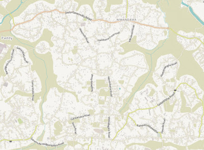
In crisis situations like an earthquake, volcanic eruption, avalanche or epidemic, first responders need up-to-date digital maps to navigate the affected area. However, many remote regions around the world simply do not have the data necessary for aid groups to safely traverse city streets and locate rural villages post-disaster. In the event of a disaster, the Humanitarian OpenStreetMap Team (HOT) mobilizes volunteer mappers around the world to focus their efforts on data deficient regions.

UVM’s HOT holds mapathons once or twice a month at a computer lab in the Aiken Center on the UVM campus in Burlington. Read about recent mapathons here: http://letters-sal.blogspot.com/2016/06/uvm-humanitarian-openstreetmap-team.html and contact mapathon coordinator Noah Ahles to be added to the notification list: noah.ahles@gmail.com Cell: 914-960-4613

Your company or organization can help support these effective volunteer events:

  • Help pay for refreshments for the volunteers!
  • Send volunteers!
  • Contribute directly to the International Humanitarian OpenStreetMap Team in honor of the UVM Team (let us know so we can thank you and give you credit!) – https://hotosm.org/donate
  • We will acknowledge your contributions at our events and at our event registration web pages.
  • Contact Noah (above) if you would like to contribute.


Map of Sri Lanka before mapathon

SriLankaBefore


Map of Sri Lanka after mapathon

SriLankaAfter


Digital Land Records in Colchester!

March 22, 2016

From the VT League of Cities and Towns Newsletter:

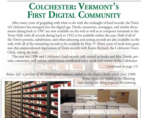
vlct_land_records

More here… http://www.vlct.org/assets/News/Newsletter/2016/vlctnews_2016-04.pdf


VCGI Update: FEMA DFIRM and Southern Orthos

February 16, 2016

State-Wide FEMA DFIRM Data Posted

A state-wide FEMA DFIRM data set (where DFIRM is available – see map) has been posted in Vermont’s Open GeoData Portal: http://vcgi.vermont.gov/opendata.  This new data posting replaces the individual county-based and town-based DFIRM data sets that were previously posted to the portal.  This new data set is catalogued in the portal with the database name EmergencyFlood_DFIRM;  It can be found by searching with the keyword “DFIRM”.

The DFIRM data set is available through the portal as a .zip package that contains shapefiles, tables, metadata files, and a .lyr file.

VCGI appreciates VT Agency of Natural Resources (ANR) staff for keeping VCGI abreast of the status of DFIRM data and providing symbology that is incorporated into the .lyr file.

NOTE:  New flood maps in Bennington County just became effective on 12/2/2015.

NOTE:  See the Flood Ready Vermont web site at http://floodready.vermont.gov/ for information on flood readiness.


All VT Imagery Service Now Includes 2015!

VCGI’s full suite of imagery services have been updated with the latest 2015 VT ortho imagery (covering southern VT).

2015 Orthos have been integrated into the following services

  • All “Best of” services + caches (color, color infrared, and black & white) have been updated
  • All statewide “ortho only” services (color, color infrared, and black & white) have been updated
  • Individual cached 2015 ortho services have been created (SP + WM)
  • The “All VT Imagery and Indexes” service (version 3) has been updated to include 2015 imagery + indexes (including tie-cut lines).

NOTE: These services also take advantage of stable “layer ids” for those hackers out there, so you can count on them staying the same when you write your code.

Additional details are available here:

http://vcgi.vermont.gov/warehouse/web_services#imagery


Survey to Collect Input on the Value of Parcel Data in Vermont

December 9, 2014

ParcelsScreenshot.285px


VTrans has engaged the services of AppGeo to perform a Return on Investment Study as well as a Parcel Lifecycle Report. They are seeking input from a wide variety of people who live or work in VT in order to gather knowledge and opinions about the value of parcel data (one of the key ingredients of a tax map). Visit the Statewide Parcel Data page to learn more ( http://vcgi.vermont.gov/parcels ) or click here to go directly to the survey: https://www.surveymonkey.com/s/VTParcelROI.


UVM Staff Award Results in Geospatial Trophy!

May 28, 2014

From  http://www.uvm.edu/~uvmpr/?Page=news&&storyID=18463

OCG Trophy_05.01.14_crop OCG Trophy_05.01.14_toponly

“Six UVM staff members were recognized for their extraordinary contributions and overall impact on the university on May 5 at the inaugural President’s Our Common Ground Staff Award recognition breakfast in Billings Library.

Honorees were chosen from a pool of 24 nominees for exemplifying the qualities of the University of Vermont’s Our Common Ground, the statement of aspirations and shared values of our community: respect, integrity, innovation, openness, justice and responsibility.

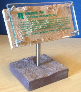
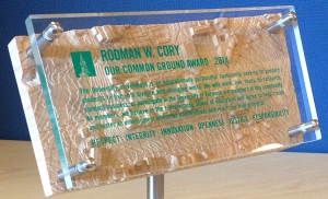
Honorees were presented with a hand-crafted award designed by local artist Chris Reck that UVM President Tom Sullivan said embodies the values expressed in the President’s Our Common Ground award. Anchored by a piece of red cambrian sedimentary rock known as Monkton quartzite used in many of the university’s buildings, the award features the Our Common Ground statement transposed on an intricate woodcarving map of the campus.”

Chris Reck of Direct Design contacted VCGI for ideas regarding who might actually create the 3D wood topo map featured in this trophy. Leslie Pelch of VCGI sent a message out on the VT GIS email list serve and several people got in touch with Chris to say they might be able to help. In the end, Spencer Wright of Bristol Contours (802-355-0800) was able to create the maple topo map of a portion of the UVM campus.


VT Interactive Map Viewer BETA 2.0 Released

April 29, 2014

imv_beta

The VT Center for Geographic Information (VCGI) is pleased to announce an “open beta release” of the new VT Interactive Map Viewer (VT Viewer).

You can participate in a guided tour during the free webinar on April 30.

This BETA 2.0 release includes numerous enhancements

  • The toolbar has been rearranged to make it more intuitive.
  • The look-and-feel of the VT GIS basemap has been significantly improved.
  • Several dozen new data layers (including parcel data) have been added to the viewer.
  • User can change the symbology of any layer.
  • Complete set of VT imagery and imagery indexes.
  • Several new supplemental background basemaps have been added such as contoured hillshade and the latest USGS Topographic Maps.
  • All layers have links to full documentation and downloadable data files.

Now we need to hear from you! Please take the new VT Interactive Map Viewer (BETA 2.0) for a test drive, then let us know what you think by completing the Feedback Survey.

VT Viewer (BETA 2.0): http://dev.maps.vermont.gov/vcgi/vtmapviewerbeta2/

User Survey: http://dev.maps.vermont.gov/vcgi/vtmapviewer/survey.html

The BETA 2.0 release will be available as an “open beta” until May 31st, 2014. After that VCGI will be reviewing all survey feedback and applying any needed adjustments/fixes to the site. We plan to release the final version by July 1st, 2014. It will replace the current VT Interactive Map Viewer.

You can participate in a guided tour during the free webinar on April 30.


VCGI Update

April 14, 2014

statehouse_0_3_2013_sm

Request for Information posted re: VT Open GeoData Portal:

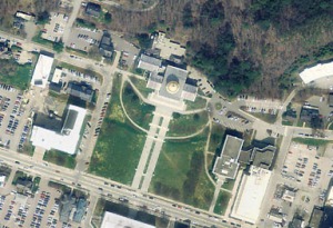
The VT Center for Geographic Information (VCGI) currently hosts Vermont’s Open GeoData Portal (herein referred to as the GeoData Portal), which allows users to access and use geospatial information and services. This Request for Information (RFI) is designed to gather information from geospatial technology providers regarding the development of a new VT Open GeoData Portal. The results of the RFI may or may not lead to the release of a Request for Proposals (RFP).

The full RFI has been posted here http://vcgi.vermont.gov/rfps

NOTE: All questions related to this RFI should be emailed to steves@vcgi.org by April 28, 2014: 3PM EST. All questions and associated responses will be made publicly available by May 5, 2014: 3PM EST on VCGI’s website.

All 2013 Orthoimagery has been posted:

Ortho imagery covering the northwest portion of the state as well as the Barre-Montpelier area was collected in the spring of 2013. All of the northwest corner was collected in 4-band color infrared as well as black and white with .5 meter pixels. Additionally, much of Chittenden County was collected at a resolution of .15 meter pixels, with the more mountainous eastern edge of the county being collected at .2 meter pixels.  The Barre-Montplelier area was collected as a resolution of .3 meter pixels.  More info here: http://vcgi.vermont.gov/2013_imagery_available

Mapping it up in VT and NH (webinar) scheduled:

VT and NH both have powerful, newly updated online map viewers.  While each viewer is customized to the state’s GIS resources, they share a common framework and much of the same functionality.  Come for a tour of the new interface(s), layers and tools for both viewers. Participants in this webinar will learn how to make maps from the layers provided by VCGI and NH GRANIT, add your own data to the maps, save your map as an image or to print, and more.

Date:  Wednesday, April 30, 2014

Reserve your Webinar seat now at:
https://www3.gotomeeting.com/register/477757118


Grants Awarded for Northern VT Parcel Mapping!

March 24, 2014

grantees_crop

14 towns will receive funding from VCGI…

The Northern Border Regional Commission, whose focus is to help address the community and economic development needs of the most severely distressed portions of the Northern Forest region, awarded VCGI a grant for $169,100 in late 2013. The purpose of the project is to provide support to a subset of towns in Vermont’s Northern Border Region so that they can successfully contract with the private sector for the creation or update of parcel data for their town that meets the VT GIS Parcel Data Standard. Planning for a successful economic future in Vermont’s Northern Border Region requires visualizing current and future conditions. Maps are a vital tool in that process, and many towns in the region are hampered by old, inaccurate, or absent parcel maps. Modern mapping requires digital map data (also called GIS data) from a variety of sources, including municipal tax maps – the source of parcel data.

VCGI and its Regional Planning Commission Partners (NRPC, LCPC, NVDA) are looking forward to working with the following towns to support their effort to create or update and improve their parcel data: Derby, Troy, Jay, Glover, Holland, Waterford, Burke, Enosburg, Berkshire, Franklin, Sheldon, Wolcott, Eden, and Elmore.  In addition to providing about $160,000 worth of financial support, RPC and VCGI staff will provide technical specifications, template documents to guide the towns through a Request for Proposals process (in some cases), a mapping contract template, and support drafting a plan for future data maintenance to keep the data useful into the future.

This project is part of a larger effort to develop a statewide parcel data program in VT to ensure up-to-date, consistent, and useful parcel data is developed and maintained for all towns. The VT Enterprise GIS Consortium oversees that effort.

For more information: lesliep@vcgi.org or 802-882-3002


VT Parcel Boundary Map Service Now Available!

February 13, 2014

Leslie Pelch, VCGI

parcel_status_map_jan2014

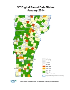
VCGI has posted a Parcel Boundaries Web Map Service that will be updated at least annually as we receive updated parcel data. Web map services allow users to bring map layers and imagery into their GIS projects or map mashups without actually downloading any data by connecting to the service of choice via the internet.

Contact Leslie (lesliep@vcgi.org or 802-882-3002) if you need help understanding how to connect to this service. More info here: http://vcgi.vermont.gov/warehouse/web_services/map